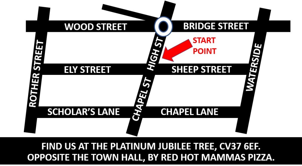
Finding us
All of the Sinister Stratford Guided Walks start at the top of Sheep Street next to Red Hot Mammas Pizza, on the corner of High Street, opposite the Town Hall, the Old Bank (HSBC) and the Garrick Inn. The postcode for Sheep Street is CV37 6EF, but that is the postcode for the whole of one side of the street, so if you can see the river and a big tower, you’re at the wrong end! There is a pin for the Platinum Jubilee Tree on Google Maps on this corner, exactly where the walks start. Though please bear in mind that that tree was only planted in 2022, so it isn’t particularly big yet!
Here is the Google Map with our pin on it.

This photo has been taken from the start point, showing what is on the other side of the roads. If these things are not where you are, you are in the wrong place!
And below is another basic map just to make sure!

Accessibility
The walk itself is fully accessible. While we obviously cannot guarantee that all the drop kerbs will be clear, their location on and near corners of streets makes it highly unlikely they will be blocked. The tour does go over cobbles and a wooden boardwalk. It is possible to hire scooters and borrow wheelchairs from Shopmobility based in Bridgeway car park, though for the Sinister Stratford guided walk, these would only be of use if you are staying in Stratford overnight as they close before our first walk has finished. For more details of that and other accessibility information, visit https://www.accessiblestratforduponavon.co.uk/.
Parking
If you are driving to Stratford-upon-Avon, we recommend using one of the district council car parks. The council car parks are exceptionally cheap, not just for a town with a big tourist economy, but compared to other nearby local authorities. Additionally, the evening charge of £3.70 (at time of publication) starts at 4pm, but given you get the first hour free, it effectively begins at 3pm if you go to the Bridgeway pay-on-exit car park, the postcode for which is CV37 6YX.
The closest car park to the start point is Church Street (notwithstanding the NCP on Rother Street), but this only opens 4pm to 8am weekdays and all day weekends and bank holidays (it’s the car park for council staff in office hours). While street parking in metered areas and on single yellow lines becomes FREE at 6pm, it is NOT recommended before then as metered street parking is limited to a maximum of one hour (or less!) in most places, though you can get two hours around Old Town and Trinity Close. If you do intend to park on the street, we strongly recommend you download the Ringo App before arrival as very few machines take coins and Ringo is a pretty horrible app.
Park and ride operates from Stratford Parkway station with the town centre drop off pick up being on Wood Street. Please note this service ceases to operate at 6.28, so would only be any use for attending the 3pm walk.
Also, please note there are many occasions when roads are closed in and around the centre of Stratford-upon-Avon for various events.
Other modes of transport
There are bike racks on Ely Street, Waterside and Bridge Street all of which can be seen on the map above. Waterside is where the river meets the canal if you need to moor your barge, and our start point is about a ten minute walk from Stratford-upon-Avon railway station (NOT parkway!!). It’s a straight walk into town which will bring you after various changes of the name of road you are on onto Wood Street and turn right at the roundabout. Most bus routes into Stratford stop on Bridge Street or Wood Street, which like all the roads mentioned in this paragraph can be found on the basic black and white map above.